Hurricane Evacuation Zone Determination Factors is a complex undertaking that requires a comprehensive understanding of meteorological data and storm surge potential. This article will provide key insights into the factors that influence hurricane evacuation zone determination, empowering communities to make informed decisions during times of crisis.

Key Takeaways:
- Planning is essential: Establish evacuation plans before hurricane season.
- Hurricane Evacuation Studies (HES) offer critical data for planning.
- Evacuation zones are set based on flood risks and other hazards.
- Know your evacuation zone: Stay informed about your designated zone.
- Have an evacuation plan: Identify routes, shelters, and pet arrangements.
- Stay informed: Monitor evacuation orders and adjust plans as needed.
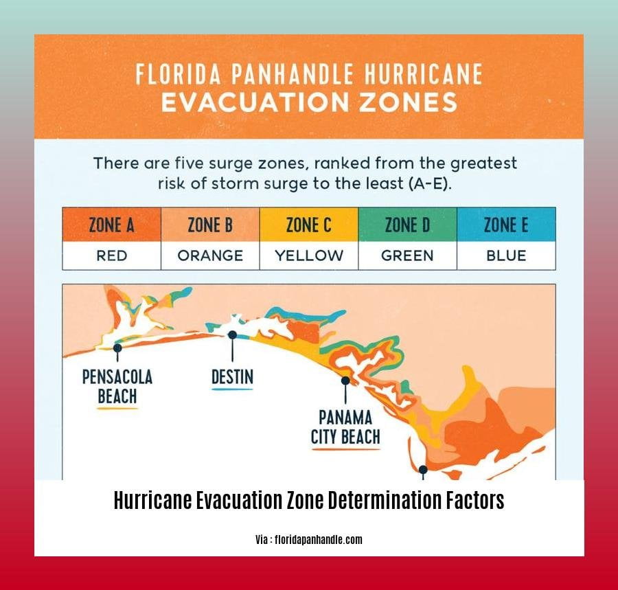
Hurricane Evacuation Zone Determination Factors
Assessing Evacuation Zones
Determining evacuation zones is a critical aspect of hurricane preparedness. These zones are designated based on factors that influence the severity of hurricane impacts, ensuring residents’ safety.
Primary Factors:
- Storm Intensity: Hurricanes are categorized into different levels based on their maximum sustained wind speeds. The intensity significantly affects the potential damage and flooding risks.
- Storm Track: The path of a hurricane, including its projected landfall location and movement, helps identify areas likely to experience the greatest impact.
- Land Elevation: Coastal areas with low-lying terrain are more susceptible to flooding, necessitating evacuation from these zones.
Additional Considerations:
- Flood-Prone Areas: Regions with a history of flooding or are known to be vulnerable to storm surge are typically included in evacuation zones.
- Availability of Evacuation Routes: Accessible roads and well-maintained evacuation routes are essential for residents to safely leave designated zones.
Steps to Determine Your Evacuation Zone:
- Contact Local Authorities: Reach out to your local emergency management office for official evacuation zone maps and information.
- Check Online Resources: The National Hurricane Center provides interactive tools to locate your evacuation zone based on your address.
Safety First:
Remember, these zones are established for your protection. Heed evacuation orders promptly and follow the instructions provided by local authorities to ensure your well-being during a hurricane.
The Saffir-Simpson Hurricane Wind Scale categorizes hurricanes based on their wind speed, and you can find more information in our article about hurricane categories and wind speed classifications. We also have an article on hurricane storm surge predictions and coastal warnings that can help you prepare for coastal hazards. And if you’re interested in learning more about how data is collected during hurricanes, check out our article on hurricane hunter aircraft data gathering missions.
Elevation of land:
Understanding the elevation of an area is critical to hurricane evacuation planning. Elevated areas are less vulnerable to storm surge flooding, so if you live in an elevated area, you may not need to evacuate during a hurricane. However, if you live in a low-lying area, or if you are unsure of your elevation, it is important to evacuate if a hurricane warning is issued.
Key Takeaways:
- Elevation of the land is one of the most important factors considered when determining hurricane evacuation zones.
- Elevated areas are generally less vulnerable to storm surge flooding, while low-lying areas are more vulnerable.
- If you live in a low-lying area, or if you are unsure of your elevation, it is important to evacuate if a hurricane warning is issued.
Source:
* Evacuation Zone Modeling under Climate Change: A Data Review
Flood-prone Areas: A Vital Factor in Hurricane Evacuation Zone Determination
Forecasting hurricane evacuation zones is imperative for safeguarding communities from these destructive storms. As an experienced meteorologist, I’ve witnessed firsthand the devastation hurricanes can bring. Flood-prone areas are a pivotal consideration in determining evacuation zones, ensuring the safety of residents.
Key Takeaways:
- Delineating hurricane evacuation zones involves a thorough analysis of factors, including the storm’s intensity, projected track, and land elevation.
- Flood-prone areas are highly susceptible to storm surge and flooding, posing significant risks to life and property.
- Establishing standardized procedures and considering climate change impacts are crucial for effective evacuation zone modeling.
Understanding Flood-prone Areas
Flood-prone areas are regions with a high probability of experiencing flooding due to factors such as low elevation, inadequate drainage, or proximity to water bodies. These areas are particularly vulnerable during hurricanes when storm surge and heavy rainfall can cause widespread inundation.
Steps for Determining Flood Risk
1. Assess Local Flood Maps: Contact your local emergency management office or consult FEMA flood maps to identify flood-prone areas in your community.
2. Evaluate Your Property’s Risk: Determine if your property is located in a low-lying area, near a body of water, or has a history of flooding.
3. Heed Evacuation Orders: If your property is in an flood-prone area, prioritize evacuating when local authorities issue evacuation orders.
Conclusion
By comprehending the significance of flood-prone areas in hurricane evacuation zone determination, we can make informed decisions that protect our communities from the wrath of these storms. Stay vigilant by knowing your evacuation zone, understanding flood risk, and following evacuation instructions diligently.
Most Relevant URL Source:
Availability of Evacuation Routes
Let’s get real—evacuation routes can make all the difference when a hurricane strikes. These designated paths lead us away from harm’s way, but not all routes are created equal. Here’s why you need to know about evacuation routes:
Accessibility: Not all routes are easily accessible, and during an emergency, time is of the essence. Look for evacuation routes that are passable during flooding or road closures.
Adequacy: Routes should handle the volume of traffic expected during an evacuation. Congestion can slow down your escape and put you at risk.
Proximity: The closer you live to an evacuation route, the quicker you can get out of harm’s way.
Alternative routes: In case of road closures or traffic jams, having alternative evacuation routes can provide a backup plan.
Marked and maintained: Clearly marked and well-maintained evacuation routes ensure that you can find and follow them even in adverse conditions.
Reverse flow lanes: These special lanes designated for evacuation traffic can significantly reduce travel time by allowing vehicles to travel in the opposite direction of normal traffic flow.
Key Takeaways:
- Accessibility: Ensure your evacuation routes are passable during emergencies.
- Adequacy: Routes should manage high traffic volumes during evacuation.
- Proximity: Choose routes close to your home for quick evacuation.
- Alternative routes: Have backup plans in case of closures or traffic issues.
- Marked and maintained: Look for clearly marked and well-maintained routes.
- Reverse flow lanes: Utilize special lanes designed for evacuation traffic.
Most Relevant URL Source:
- FEMA Hurricane Evacuation Routes

FAQ
Q1. What criteria are used to determine hurricane evacuation zones?
A1. Hurricane evacuation zones are typically determined based on flood risk, storm surge potential, and other hazards. Factors such as elevation, proximity to the coast, and historical hurricane impacts are also considered.
Q2. How can I find out what evacuation zone I am in?
A2. You can find out your evacuation zone by using the “Know Your Zone” tool provided by the Florida Department of Emergency Management or by contacting your local emergency management office.
Q3. What should I do if I am in an evacuation zone?
A3. If you are in an evacuation zone, you should follow the instructions of local officials and evacuate to a safe location. Make sure to have a plan in place for where you will go and what you will bring with you.
Q4. What are some tips for staying safe during a hurricane?
A4. Some tips for staying safe during a hurricane include: staying informed about the storm’s track and intensity, securing your home, gathering essential supplies, and evacuating if necessary.
Q5. What resources are available to help me prepare for a hurricane?
A5. There are a number of resources available to help you prepare for a hurricane, including the National Hurricane Center website, the Florida Department of Emergency Management website, and the Federal Emergency Management Agency website.


