Discover the principles and techniques used to pinpoint the epicenter of an earthquake in our comprehensive guide, Locating the Epicenter of an Earthquake: Principles and Techniques. This article will delve into the methodologies employed by seismologists to determine the precise location of these powerful events.
Key Takeaways:

- Determine the distance to the epicenter using the time difference between P-waves and S-waves.
- Triangulate the epicenter by using data from multiple seismic stations.
- Calculate the precise epicenter based on the distances from multiple stations.
Locating the Epicenter of an Earthquake
Determining the Ground Zero
An earthquake’s epicenter, the point on the surface directly above the quake’s origin, is crucial for emergency response and scientific study. Here’s a guide to locating the epicenter of an earthquake:
Steps Involved in Locating the Epicenter of an Earthquake
1. Gather Seismic Data:
Collect data from multiple seismic stations, which record the arrival times and amplitudes of earthquake waves.
2. Calculate Time Difference:
Determine the time difference between the arrival of the P-wave (primary wave) and S-wave (secondary wave) at each station.
3. Estimate Distance:
Use the time difference to estimate the distance from each station to the epicenter using a travel time curve.
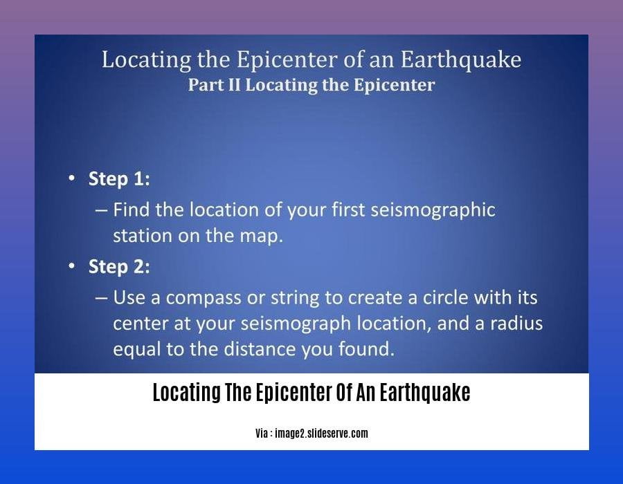
4. Draw Distance Circles:
Plot the seismic stations on a map and draw circles with radii equal to the estimated distances.
5. Locate Epicenter:
The point where the circles intersect is the estimated epicenter.
Tips for More Accurate Results
- Use data from multiple seismic stations for triangulation.
- Consider the depth of the earthquake, which can affect wave propagation.
- Refine the epicenter location using advanced techniques like grid search or beamforming.
Significance of Epicenter Determination
Locating the epicenter is crucial for:
- Directing emergency response efforts
- Understanding earthquake mechanisms
- Assessing seismic hazards
Ever wondered how scientists measure the strength of earth-shaking? Dive right into earthquake magnitude and intensity scales explained to unravel the mysteries behind quantifying seismic events.
Got curious about the potential impacts of an earthquake on structures and communities? Modified Mercalli Intensity Scale damage descriptions provides detailed insights into the severity levels and their implications.
To quench your thirst for knowledge on the differences between two prominent earthquake measurement scales, explore moment magnitude vs richter scale comparisons.
Draw Circles on a Map
Key Takeaways:
- Earthquake epicenters can be located using data from seismic stations.
- The distance to the epicenter can be estimated by calculating the time difference between P-wave and S-wave arrivals.
- Drawing circles on a map can help determine the epicenter location.
- Multiple seismic stations provide more accurate results.
- Locating the epicenter is crucial for emergency response and research.
Steps to Draw Circles on a Map:
- Collect data from multiple seismic stations around the earthquake’s epicenter.
- Calculate the time difference between the arrival of the P-wave and S-wave at each station.
- Plot the seismic stations on a map and draw circles with radii equal to the distance from each station to the epicenter.
- Measure the distance from each station to the epicenter and calculate an average distance.
- Refine the epicenter location using triangulation methods or advanced techniques if necessary.
Most Relevant URL Source:
Locating Earthquake Epicenters
Calculate the Distance to the Epicenter
Hey, there!
Let’s understand how to calculate the distance to an earthquake’s epicenter.
Measuring the distance
Step 1: Record the Waves
To start, we need data from seismic stations that record the P-wave and S-wave arrivals. The P-wave arrives before the S-wave.
Step 2: Time it Right
Next, calculate the time difference between the P-wave and S-wave arrivals.
Step 3: Use the Travel Time Curve
With that time difference, consult a travel time curve. This curve tells you the distance to the epicenter based on the time difference.
Pinpointing the Epicenter
Step 4: Multiple Stations
Multiple seismic stations give us different distances to the epicenter.
Step 5: Draw the Circles
Now, let’s draw circles on a map. Each circle represents the distance from a seismic station to the epicenter.
Step 6: Where they Meet
The epicenter is where all the circles intersect. That’s where the earthquake happened!
Key Takeaways:
- Record P-wave and S-wave arrivals from multiple seismic stations.
- Calculate the time difference between the waves.
- Use a travel time curve to determine the distance to the epicenter.
- Draw circles on a map with radii equal to those distances.
- The epicenter is where the circles intersect.
Learn more about calculating the distance to an earthquake’s epicenter
Refining the Epicenter
Key Takeaways:
- Epicenters are located by triangulating data from multiple seismic stations.
- Precise estimation requires data from stations distributed around the epicenter.
- Refining the Epicenter: Advanced techniques enhance precision.
Seismic Waves and Time Difference:
Earthquakes generate seismic waves—P-waves and S-waves—that travel at different speeds. Measuring the time difference between their arrival at various stations reveals the distance to the epicenter.
Circles of Distance:
Using this distance data, scientists draw circles around each seismic station with radii equal to the distance to the epicenter. These circles intersect at the epicenter’s estimated location.
Triangulation and Refining the Epicenter:
With data from three or more stations, the epicenter can be triangulated. Refining the Epicenter involves advanced methods like grid search or beamforming, pinpointing the location with greater precision.
Accuracy and Impact:
Accuracy depends on the number and distribution of seismic stations. Precise epicenter determination aids emergency response, scientific research, and seismic hazard assessment.
Citation:
- Michigan Technological University:

FAQ
Q1: What is an earthquake’s epicenter?
A1: The epicenter is the point on the Earth’s surface directly above the hypocenter, the point where the earthquake rupture starts.
Q2: How do scientists locate the epicenter of an earthquake?
A2: Scientists use data from multiple seismographs to determine the time difference between the arrival of the P-wave and S-wave at each station. They then use this information to calculate the distance to the epicenter from each station and plot circles on a map. The epicenter is located at the point where the circles intersect.
Q3: What is the difference between the P-wave and S-wave?
A3: The P-wave is the primary wave, which is the fastest seismic wave and travels through both solids and liquids. The S-wave is the secondary wave, which is slower than the P-wave and travels only through solids.
Q4: How can the amplitude of a seismic wave help locate the epicenter of an earthquake?
A4: The amplitude of a seismic wave is a measure of its height. The amplitude of the strongest wave can be used to estimate the magnitude of the earthquake and help determine the epicenter’s location.
Q5: What are some of the challenges in locating the epicenter of an earthquake?
A5: Some challenges in locating the epicenter of an earthquake include:
* The presence of noise and other seismic signals that can interfere with the data from the earthquake.
* The uneven distribution of seismograph stations, which can make it difficult to get data from all directions.
* The complex nature of the Earth’s structure, which can affect the propagation of seismic waves.


